geo-sleuth
An agent skill that finds where a photo was taken, OpenStreetMap geometry, elevation skylines, satellite imagery and street view, and shows its work. Works with Claude Code, Codex, Cursor, Gemini CLI, OpenCode and GitHub Copilot.
Runssource: GitHubPythonMITcommit e753bb3aad19
Python, MIT licensed. The project labels itself: agent skills, ai agents, claude code, codex, computer vision, cursor, gemini cli and geoguessr.
geo-sleuth runs. An Argusic agent installed it in 6 minutes and hit 4 errors on a clean machine with no GPU, and the whole session was recorded.
uv was installed into a venv and every script's dependencies resolved via uv run; the geo-sleuth skill's core scripts (clues, geo, board, sun, exif, imgprep, terrain, tiles, evidence, ocr, match, sat_scan, intake, baidu_pano) all executed real end-to-end runs with decoded media output, two input edge-case bugs were fixed in sun.py and sat_scan.py, and only the Overpass-backed gazetteer/osm queries failed due to unrea...
What the agent ended up with on a clean machine, in its own words. How this is measured
Measured by Argusic on a fresh machine every time. Every number links to its evidence. Argusic Score 95 of 100 (the mean of this project's run scores).
At a glance
Subject data from GitHub, linked at the top of this page, refreshed . Test data by Argusic (CC BY 4.0); every number links to a run page with the full log, the recording, and their sha256 hashes.
What was measured
From the run that decided this verdict. Every line is a recorded value, not an estimate.
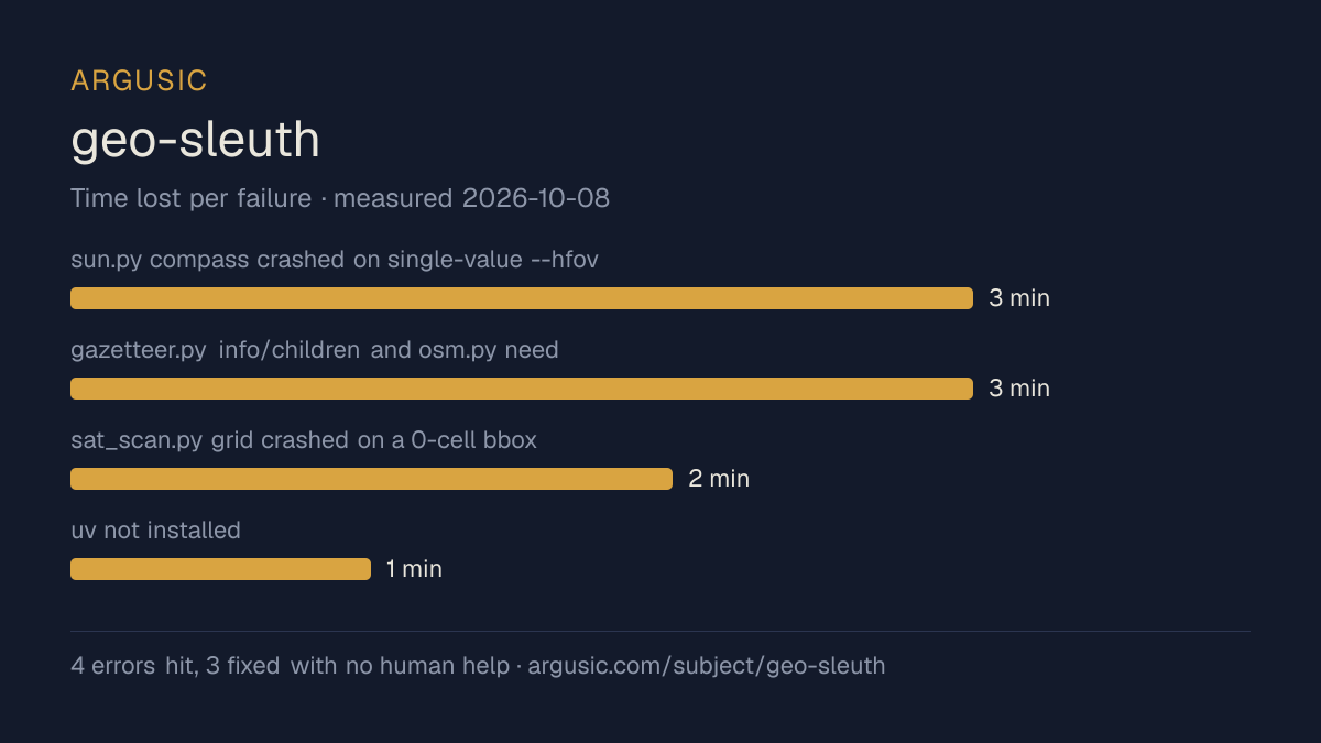
What went wrong, in the agent's own words
The agent's own words, worst first, never rewritten into advice.
- sun.py compass crashed on single-value --hfov 65 (ValueError: not enough values to unpack)3 minutes
- gazetteer.py info/children and osm.py need OSM Overpass, unreachable from this container's egress (Apache error page retried 3x)3 minutes
- sat_scan.py grid crashed on a 0-cell bbox (ValueError: need at least one array to concatenate)2 minutes
- uv not installed; scripts require uv run1 minute
- Install time
- 6 minutes
- Cold machine to finish
- 23 minutes
- Errors hit and fixed
- 4 hit, 3 fixed with no human help
- How the result was proved
- uv run skills/geo-sleuth/scripts/clues.py lookup plate 粤B returned 广东省/深圳市; terrain.py elev 35.3606,138.7274 returned '3750 m'; match.py rank --method dino ranked identical photo #1 with 1927 inliers; sat_scan.py grid ranked 20 real satellite cells; baidu_pano.py near returned a real panoid; all generated PNG/JPG/ridge decodes via 'ffmpeg -v error -i FILE -f null -' exit 0
- Model tokens used
- 152,587
- Exact commit tested
- e753bb3aad19
- Container image
- sha256:cdd920bce783
What was not measured
The other half, so you can see exactly how far this evidence goes. A gap is printed as a gap and never filled in.
- Peak GPU memory
- this ran on a CPU machine, so there was no GPU to sample
- Behaviour over a long run
- each attempt uses the smallest documented settings and a fixed time budget, so this measures whether it runs, not how it holds up under load
The end of the recording
The last lines of the terminal session that decided this verdict, exactly as they were recorded.
- `sun.py pos/ratio/dish/compass` → real NOAA sun math.
- `terrain.py elev 35.3606,138.7274` → `3750 m` (real AWS elevation tile); `terrain.py ridge` on th…
- `tiles.py fetch` → real Google satellite mosaic, `failed_tiles: 0`; `px2ll` round-trip; `evidence…
- `ocr.py` (rapidocr) detected `GD` on the photo; `match.py` (DINOv2+SIFT) ranked the identical pho…
- `baidu_pano.py near` → returned a real panoid + WGS84 coords (keyless API).
- Every generated media file decoded cleanly via `ffmpeg -v error -i FILE -f null -` (exit 0).
## Errors found & fixed (in-repo code)
- `sun.py compass` crashed on a single-value `--hfov 65` (`ValueError: not enough values to unpack`…
- `sat_scan.py grid` with 0 grid cells crashed in `np.concatenate([])`; patched to emit a clear dia…
## Errors that couldn't be fixed here
- `gazetteer.py info/children` (and `osm.py`) depend on OpenStreetMap Overpass, unreachable from th…
- `ocr.py` printed `onnxruntime pthread_setaffinity_np` warnings (CPU-affinity limits in the contai…
Replay the whole session, every command from a clean machine to this point.
How it was tested
One agent, one container, no human help. It installs the project the way its own documentation says to, runs it, and fixes what breaks. Everything below is recorded as it happened: the terminal session, the log and the exact commit. The full method.
Strengths and limits
Measured facts, not opinions. How this is written.
What went well
- Reached a running state on a clean machine, with the session recorded.
- Ran without a GPU, so it does not need one to start.
- Licensed MIT, as reported by its host.
What did not, or is not known
- Took 6 minutes to install, slower than the median of the 46 comparable projects Argusic has measured.
- Hit 4 errors during setup, 1 of which were not solved.
- Measured once so far. A single attempt shows it can run, not that it runs reliably.
Of the 47 agent-skills projects Argusic has installed and timed, geo-sleuth was the 35th fastest to reach a running state, and 33 of 47 reached one at all.
What it is a reasonable choice for
- Trying it on a laptop or a small server: it reached a running state without a GPU.
- A quick evaluation: it was running 6 minutes after the clone.
Also tested, in the same area
Every one of these was installed and run by Argusic on a clean machine. Nothing appears here that was not tested.
Run history
Topics (from GitHub)
agent-skillsai-agentsclaude-codecodexcomputer-visioncursorgemini-cligeoguessrgeointgeolocationgithub-copilotimage-geolocationopencodeopenstreetmaposintphoto-geolocationreverse-image-searchsatellite-imagery
Embed the badge
Markdown for the project README. It links back here; terms on the terms page.
[](https://argusic.com/subject/geo-sleuth)Questions
- Does geo-sleuth run?
- Yes. geo-sleuth runs. Argusic installed and launched it on a clean machine in 6 minutes, hitting 4 errors on the way, and recorded the session.
- How did Argusic test geo-sleuth?
- On a fresh, disposable machine, with every command recorded and the repository pinned at commit e753bb3aad19. One attempt is recorded, and the full method is on the methodology page.
- What did it cost to test geo-sleuth?
- The run that produced this verdict cost $0.12: real compute and model cost, not a list price per million tokens. It is recorded on that run's page.
- How long does geo-sleuth take to install?
- 6 minutes in the run that decided this verdict, from a clean machine to a running state. That is one measured attempt, not an average.
- Does geo-sleuth need a GPU?
- Not to start. Argusic reached a running state on a machine with no GPU.
- What goes wrong when installing geo-sleuth?
- 4 things broke in the recorded run, and 3 were fixed without human help. Each one, and the time it cost, is listed on this page.
- How does geo-sleuth compare with the alternatives?
- Of the 47 agent-skills projects Argusic has installed and timed, geo-sleuth was the 35th fastest to reach a running state, and 33 of 47 reached one at all.
- Where is the evidence for geo-sleuth?
- The recorded run is on this page, each linking to its full log and terminal recording, stored with a sha256 fingerprint so it cannot be quietly altered.